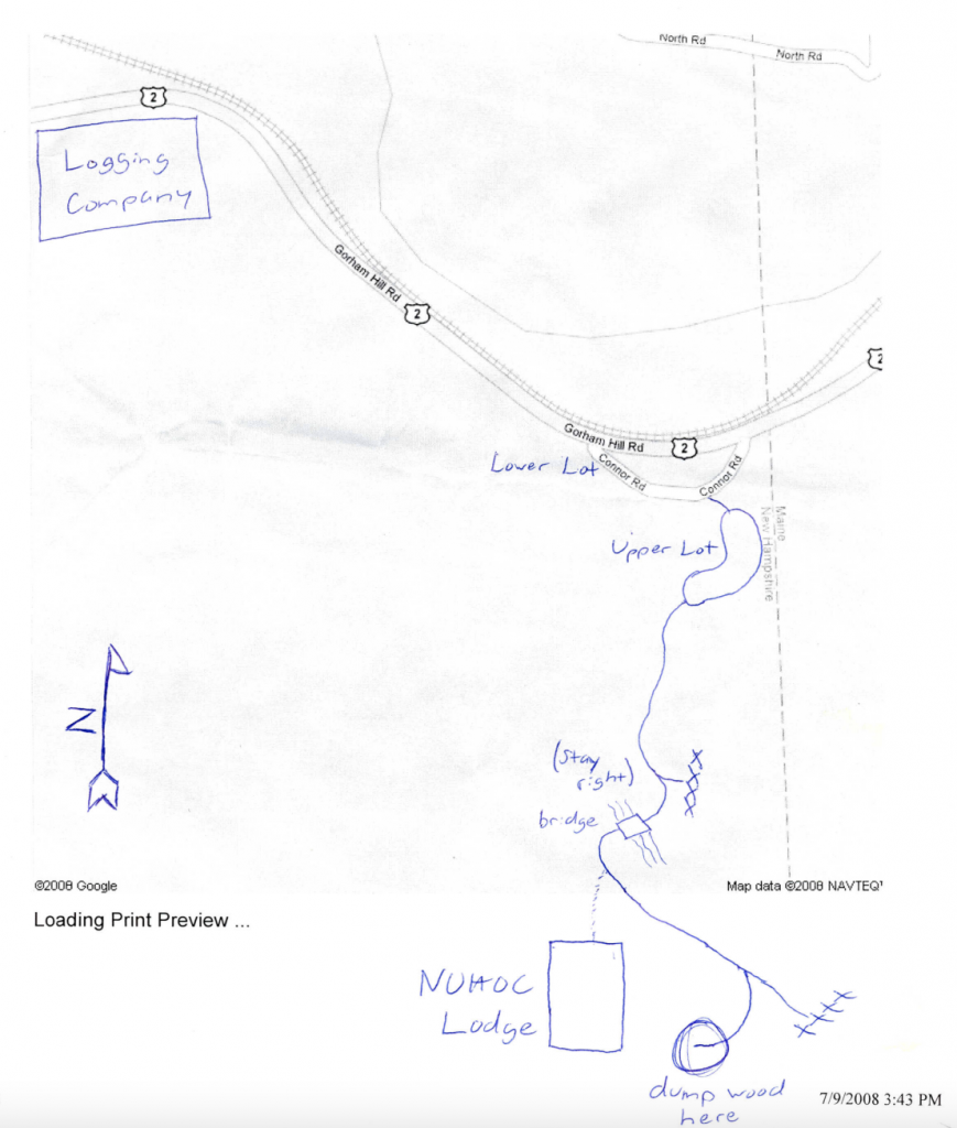
Driving Directions
If you’ve never been to the Loj before, you might be wondering how to get there!
If you’re using a maps app, you can use 44.3846326, -71.0165923 as the address to get the approximate location of the Loj and then follow the directions listed below to find the Loj road and the parking lot. Cell service is spotty in many parts of New Hampshire, so it’s a good idea to download an offline map as well if possible.
Getting to the Loj
- From Boston, take I-93 north toward Concord.
- If you’re stopping at Market Basket, it’s located at 108 Fort Eddy Rd, Concord, NH 03301. Take exit 14. Go straight, then at the third traffic light, take a right into the parking lot. The Market Basket will be on your left once you’ve turned into the parking lot.
- Otherwise, continue north on I-93 for another 70 miles until you get to exit 35. It will be the first green exit sign after a series of brown exit signs. The exit is onto US-3 N.
- Follow US-3 for 12 miles, then take a right on NH-115 N.
- At the end of NH-115 (about 10 miles later), turn right onto US-2 E.
- Follow US-2 E for about 12 miles. At the traffic light, turn right to continue onto US-2 E into Gorham. (The Gorham police like to pull people over for speeding, so don’t go over 35 mph while you’re in the town.)
- Continue on US-2 E for another 10 miles. When you’ve crossed the railroad tracks on the way out of Gorham, the speed limit changes back to 50 mph.
- When you see a sign for RJ Chipping Enterprises on the right side of the road, begin to slow down – you will reach the turn off in less than two minutes.
- When you see a green “Maine State Line” sign in the distance, really slow down and look for the turn off. A couple hundred feet before the Maine sign, you will see a gravel road between a white mile marker and a green mile marker. Turn onto the gravel road.
Parking
- There are two parking lots: the lower parking lot and the upper parking lot.
- To get to the lower parking lot, go up the gravel road and take a right at the fork.
- We park in the lower parking lot in the winter (typically December-April – basically when there’s snow/ice/mud on the ground) or if the upper parking lot fills up. If there’s too much snow and ice to get there, we often just park on the side of the gravel road before the actual parking lot. If you do this, make sure not to obstruct other vehicles.
- To get to the upper parking lot, go up the gravel road and take a left at the fork, then drive for a few hundred feet up a small hill and you will see a big open parking lot.
- To get to the lower parking lot, go up the gravel road and take a right at the fork.
- The gravel road is bumpy. If your car has a low undercarriage, the gravel may scrape the bottom of the vehicle, so you might be better off parking in the lower parking lot.
- No matter where you park, make sure not to block the road. We are not the only ones who use the gravel road, and sometimes vehicles may need to drive up past the upper lot to carry supplies etc.
Walking from the parking lot to the Loj
From the far end of the upper parking lot, keep walking up the dirt road. Follow this path until you reach a fork in the road. Keep right at the fork and cross over a wooden bridge. You should see a big white propane tank in front of you. Keep following the trail up a small hill. After fifty feet or so, there will be a path on your right with some stairs and a sign that says “WILD WILLEY TRAIL.” Follow these stairs up to the Loj.
